MANILA, before and after...
Did you know that Manila was designed to follow what is called the "City Beautiful" architecture? The design combines classical architecture with wide open spaces, tree-lined avenues, sea views. Manila was designed to be in the same league as Washington DC, San Francisco, Australia, France.
Mr. Burnham, the guy who designed Washington – yes, the same architect who designed Baguio and Burnham Park – came to Manila in 1904 and submitted his plans and recommendations on how to convert Manila to a "City Beautiful." (He basically copied the Washington plan.)
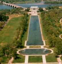
Washington, DC – Lincoln Memorial (2006), photo below


Rizal Park, Google photo

Looking at the photographs of old manila, you'd think that it's a European city. (PHOTO ABOVE)
Below is Escolta in 1899, the financial capital of the Philippines until the 1960s. Notice the statue columns at the Top-left of the picture, very nice.


Escolta (2006), The building w/the statue columns is gone.
Those columns are now at someone's house in quezon city.
Jones
Bridge (before 1910), See the chesterfield sign? That's where the bridgeview restaurant used to be.
Jones
Bridge (2006)
At the foot of
Jones Bridge (before 1920) This is passing bridgeview.
At the foot of
Jones Bridge (2006), the red/cream building at the far left is still intact and is a bank.
If you noticed, Old Manila follows European Traffic – i.e. traffic flows from the right.
Manila only started driving at the left side when it was under American rule.We're still going further using the same street, Rosario/Quentin Paredes (before 1920) This is the street that goes straight to
Binondo Church . I'm not sure if you can see it but if you follow the street, at the end of the trail, you can actually see a faint outline of the dome of the church.
Rosario/Quentin Paredes (2006)

San Fernando
(before 1920) looking out to Binondo Church . This is the place where Uncle Tony's ( a kinfolk of the original contributor ) old apartment was located..

Rizal Avenue
(1930) Still remember going to the Teng's shop in Raon? =) Notice the European-type traffic flow?

Avenida Rizal, 2006..
The only surviving building from 1930 is covered by one the pillars at the right. This area been converted to a pedestrian only walkabout. It's is under a mass railway transit.

Old view of Plaza Goiti. (Where again is Plaza Goiti?)

Carriedo (1900) This is at the foot of the quezon blvd bridge that goes
straight to
Sta Cruz Church. (Or near the 1st SM shop of Henry Sy.)
Carriedo (2006)
Makati Skyline- 2006 (photo below)

I can't help but notice that Old Manila looks much cleaner than our present times.
Believe me, the air in Manila is fresh and clean…if you manage to go beyond escape velocity altitude...(Maybe above 30, 000 ft.?)
THE END
Photos and text contributed by
Alfredo Rodillas,
Florida


No comments:
Post a Comment